|
|
|
P.I.R.A.T.E.S (AS IT WAS IN 2011) Program Integrating Radiogoniometry and Analysis Techniques using the Spectrum Explorer Programme Intégré de Radiogoniométrie et d'Analyses Techniques avec l'Explorateur du Spectre Page 1
P.I.R.A.T.E.S. stands for “ Program Integrating Radiogoniometry and Analysis Techniques using the Spectrum Explorer “. The acronym comes from the French translation, which is “ Programme intégré de radiogoniométrie et d’analyses techniques avec l’explorateur du spectre “.
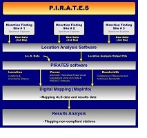
P.I.R.A.T.E.S. is an integrated system of hardware and software which makes it possible to quickly detect and locate illegal and non-compliant stations in the radio frequency spectrum, in terms of location, power and bandwidth. The system also makes it possible to plot on a map and to flag suspect stations for further investigations.
The Wideband Direction Finder of the Spectrum Explorer (SE/DF) is a software module that enables the Spectrum Explorer to calculate the angle-of-arrival of detected signals while scanning at speeds of up to 20,000 channels per second.
In order to carry out a P.I.R.A.T.E.S. operation, the following conditions must be met:
Two or more DF sites must be scanning simultaneously (more than 2 DF sites give better results) Each DF site must be using a wideband direction finder and a wideband DF antenna DF Sites must be located so intersection of directions is optimized within the targeted zone Same scan table must be used at all DF sites Scanning at all DF sites must be "time synchronized" trough GPS All recorded measurements must be time stamped (time stamping is essential) Stations must be heard by at least two DF sites for measurements to be analyzed
When a signal is detected at each DF site, technical parameters are measured and the results are saved in a text file. Measurements include the direction (angle-of-arrival), the frequency, the bandwidth, and the signal level.
The text files from each DF site containing the saved data are brought to a central location at the end of the scanning session where they can be merged and processed using the software ‘Location Analysis’. This software uses the angle-of-arrival of the detected signals which meet the preselected criteria of fixed base stations in order to calculate the location of the stations and to generate the technical parameters needed to draw an ellipse of uncertainty around each station.
The P.I.R.A.T.E.S. program working with MapInfo makes it possible to display on a map the calculated locations of the detected stations as well as their uncertainty zones (ellipses) based on the quality of the measurements. The program also displays all authorized stations in A.L.S. within the targeted area.
If there is no A.L.S. authorized station on the same frequency as the detected station inside or near the uncertainty zone, the detected station becomes suspect and is flagged for further verifications. It could be an unlicensed station, a licensed station which has been relocated without authority, a station with an expired license which has continued to operate after the expiry date, etc...
There are other verifications which can also be made using power and bandwidth measurements. Additional data is available to assist in further analysis such as the list of stations not included in A.L.S. for security reasons (A.L.S. is available to the public), FRS and GMRS frequencies, short terms and temporary frequency assignments, and the occupancy data from T.M.R.S. (Technical Measurements Reporting System).
For a better understanding of how P.I.R.A.T.E.S. works, you can view a presentation by clicking below. |
|
|